Arkansas is not a state that is well known for its uranium deposits. When our geologists found out about the black shale deposits in Yellville, we HAD to investigate!
Here is an artist's rendering of the outcrop as it looked in 1962.
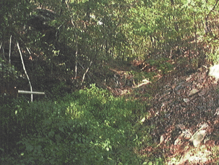
Here is what it looked like in 1999.
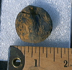
This little nugget made the counter go nuts! It is probably at least .7 percent uranium!
Geology of a Uranium-Bearing Black Shale of Late Devonian Age in North-Central Arkansas
By Vernon E. Swanson and Edward R. Landis USGS (1962)
Information Circular No. 22
At an exposure of black shale in Marion County, Ark., samples were collected that have the highest uranium content yet reported from black shale in the United States. The most uraniferous samples collected by the authors contained 0.55 percent uranium, but a shale sample from the same locality with a uranium content of 0.71 percent has been reported. Less than 1 ton of highly uraniferous shale is present at the locality, but the geologic relations are significant because they suggest specific conditions under which uranium may be syngenetically concentrated in marine black shale. The study of this and other nearby deposits in the Chattanooga shale in north Arkansas was made as part of an investigation on behalf of the U. S. Atomic Energy Commission of uranium-bearing black shale in the Midcontinent region.
The locality was first visited in May 1955 by Swanson in the company of Mr. C. E. West of Bentonville, Ark., who had detected the anomalously radioactive shale while prospecting in the area. Representative samples were collected at this time; and the locality was studied and sampled in more detail during subsequent visits by the authors in June 1955, by Landis in November 1955, and by Swanson in June 1958. The type section of the Sylamore sandstone member and many other outcrops of the Chattanooga shale in Arkansas have also been studied.
A suite of shale samples was submitted to James M. Schopf, U. S. Geological Survey, for petrographic study of the organic matter, and another collection was submitted to the late Wilbert H. Hass, U. S. Geological Survey, for fossil determinations. The authors gratefully wish to acknowledge the descriptive material and data determined by Schopf and Hass and used in the preparation of this paper.
GEOLOGIC SETTING
Location
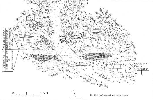
The outcrop of black shale is located in the NE1/4SW1/4 sec. 11, T. 19 N., R. 17 W., Marion County, Ark. (fig. 1), near the head of a small, south-trending ravine that opens onto Georges Creek, which is about 1 mile south of the outcrop. The outcrop is reached by following an old logging road for about 200 yards south-southeast of Arkansas Highway 14; this logging road, which can barely be detected from the highway, enters onto Arkansas Highway 14 5.2 miles southeast of the junction of Arkansas Highways 14 and 125. The locality may also be reached by traveling 11.0 miles on Arkansas Highway 14 from the intersection of this highway with U.S. Highway 62 at the northwest corner of the square in Yellville, the county seat of Marion Counts.
About 150 yards south and down the ravine from the outcrop of black shale are the ruins and dumps of the old Bear Hill zinc mine, last operative in 1917. The zinc ore was mined at depths between 100 and 200 feet stratigraphically below the black shale, from the lower part of the Everton formation and the upper part of the Powell dolomite, both of Ordovician age.
Stratigraphy
Marion County lies on the highly dissected southwest flank of the Ozark uplift where rocks of Ordovician age are widely exposed. Only on the high ridges are younger rocks of Paleozoic age present, and then generally of only one formation, the Boone formation of Mississippian age. The rock unit of special interest in this report is found at the contact between these Ordovician anti Mississippian rocks. McKnight (1935) presented a comprehensive report on the zinc and lead deposits of northern Arkansas, which included a geologic map of the Yellville quadrangle that covers most of Marion County, Ark.; his report served as the basis for much of the general geologic description given here.
The highly uraniferous material was collected from a shale lens in a sandstone that was called the "basal sandstone of the Boone" formation by McKnight (1935, p. 68).
This sandstone is a persistent unit at the base of the Boone formation in Marion County and parts of adjacent counties of north-central Arkansas, and rests upon a broad, plane surface that unconformably cuts across several formations of Ordovician and Silurian ages. The sandstone is generally a few inches to 5 feet thick, but in a few areas it is between 5 and 12 feet thick. In the Yellville quadrangle, this sandstone is everywhere overlain by the distinctive crinoidal, reddish St. Joe limestone member of the Boone formation.
The sandstone at the base of the Boone formation is known to contain black shale at two other places in the Yellville quadrangle. Both places were noted by McKnight (1935, p. 69), and are located near Everton, Ark., about 14 miles airline southwest of the locality described in this report (fig. 1). Maher and Lantz (1952, p. 10; 1953) observed three similar occurrences of black shale in this sandstone about 25 miles to the south, two in central Searcy County and one in eastern Newton County (fig. 11. Thus, 6 localities are known, and there is little doubt that local lenses or pockets of black shale in the sandstone are present at many other places in the area to the north and east of the zero-isopatch line of black shale as shown in figure 1.
CHEMICAL DATA
Uranium
Attention was first called to the black shale of central Marion County by Mr. C. E. West of Bentonville, Ark., who had observed the abnormally high radioactivity of the shale while prospecting. Using a Geiger counter, Mr. West collected and submitted 2 samples of the most radioactive parts of the shale through the U. S. Atomic Energy Commission to the U. S. Geological Survey laboratories for uranium analyses. One of these samples contained 0.71 and the other 0.12 percent uranium. On being informed of black-shale samples that contained about 100 times more uranium than black shales commonly contain, Swanson made arrangements with Mr. West to visit the locality with him. The exact location and stratigraphic position of Mr. West's samples were thus determined and the study which led to this report was initiated.
Shale, as the most abundant type of sedimentary rock, contains an average of 0.0003 or 0.0004 percent uranium. Black shales probably have an average of 0.0008 percent uranium; and marine black shales, excluding the thick marine black shales deposited in geosynclinal areas, have an average uranium content of about 0.0020 percent and a general range of 0.0008 to 0.0250 percent. Prior to the discovery of the marine black shale in Marion County, the highest uranium content of samples from a marine black shale in the United States was found in coaly Callixylon remains from the Gassaway member of the Chattanooga shale near Nashville, Tenn. This coaly material contained 0.025 to 0.035 percent uranium, and has been described by Breger and Schopf (1955). Greater concentrations of uranium in a marine black shale have been known for many years, however, from descriptions and analyses of kolm lenses (0.1 to 0.7 percent uranium) in the alum shales of southern Sweden.
Samples of the Chattanooga shale from 18 localities in Arkansas, Oklahoma, and Missouri have an average uranium content of 0.0020 or 0.0030 percent, with a range of less than 0.0010 percent to 0.013 percent (Landis, 1958, p. 202-203). Bulk shale at the localities northeast of Everton and in central Marion County contains an average of about 0.0060 percent, with a range of 0.0020 to 0.0120 percent.
Return to Uranium Minerals
Return to Main